HEBDEN BRIDGE WALKERS ACTION
906 BUS WALKS 6
Midgehole to Oxenhope
via Haworth Old Road
Main features of the walk
This walk follows the old route that connects the Calder and Aire Valleys. It has fantastic panoramic views of both valleys.
Length and time
It’s about 10 km (approx 6½ miles) and should take you about 3 hours (+ stops).
Gradients – how strenuous?
There are two longish climbs and two descents.
Terrain – how uneven?
The walk is all on well signposted tracks, but some parts can be very muddy.
Obstacles – stiles, steps etc.
There are a number of gates on the route.
Facilities on the walk
There are toilets at the start at Midgehole (20p). Otherwise, are no facilities on the route, but the walk ends at Oxenhope where you may want to visit the Station café or one of the two village pubs.
What to take?
Because of muddy sections, you really need boots for this walk. It is quite exposed on the top of the walk, so make sure you have clothing to deal with wind and rain. Also take a timetable for the 500 bus to bring you back to Hebden Bridge.
Detailed directions for walk 6: Midgehole to Oxenhope via Haworth Old Road
This walk starts at the 906 bus stop at Midgehole.
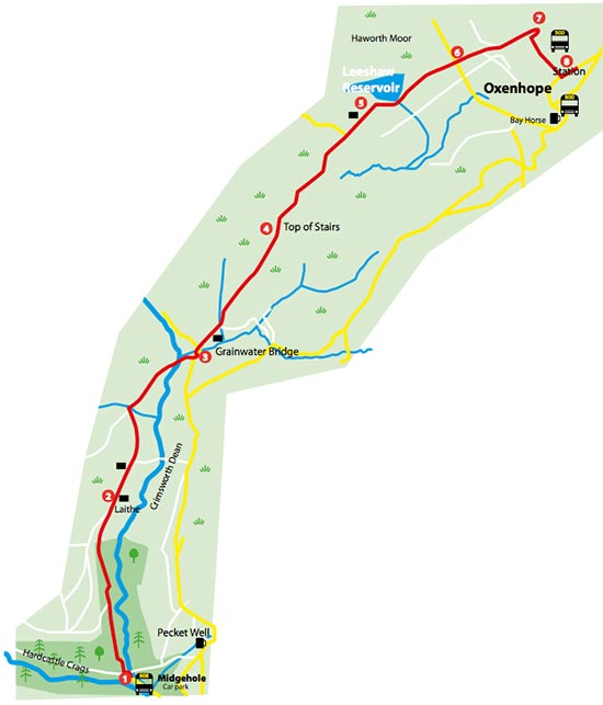
- Take the bridleway on your right just after the Welcome to Hardcastle Crags sign. At the top of this walled path, turn right on to the tarmac track. From here you follow this track straight ahead for 2½ km. It’s a steady uphill climb through some woodland on to upland grazing.
- You pass Laithe farm on your right, then a derelict farm on your left (can be muddy) and then, still on the track, gently drop down to a bridge where you go straight ahead.
- When you reach the tarmac road, you turn left heading uphill sign-posted ‘Calder Aire Link Bingley 13 miles’. There is now a 1km steady climb to ‘Top of the Stairs’ (ignore tracks going off to the left and right).
- At the top, the track levels out and follows a wall and the Aire Valley comes into view. From here the track gently descends through a gate and then goes down more steeply, past a farm on your left.
- Reaching Lower Laithe Reservoir, the track bears right and then left below the dam, eventually coming out on a tarmac road by the reservoir gates where you turn right.
- After ½ km, at a cross roads, you go straight ahead on to Marsh Lane. Having passed a chapel, and after another ½ km, you reach a road on your right, sign-posted ‘Oxenhope and Hebden Bridge’.
- The bus stop for the 500 bus back to Hebden Bridge is 100 metres farther on.